Asian Monsoon Variability from Climate Models and Proxies
Background
The Asian Monsoon is a dominant feature of global atmospheric circulation, controlling regional climate variability in South, Southeast, and East Asia. With over a billion people directly or indirectly dependent on sufficient monsoon rains for subsistence and economic well-being, widespread socioeconomic impacts can result from a weakening or even failure of the monsoon rains during the boreal summer monsoon. Robust changes in Indo-Pacific climate over recent decades heighten the need for improved understanding of Asian monsoon variability on extended timescales and their links to Indo-Pacific conditions on a range of timescales from seasonal to decadal and beyond.
A network of high-resolution paleoclimate proxy reconstructions from tree rings covering the last millennium has opened new possibilities for understanding variability in hydroclimatic conditions across monsoon and temperate Asia: The Monsoon Asia Drought Atlas (Cook et al. 2010). As such, it offers an extended climatic record at annual resolution across a densely populated region, which is reliant on monsoon rainfall but has limited coverage of instrumental climate data over extended periods, as well as across remote, sparsely-populated regions in central Asia with limited observations.
Summary
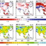
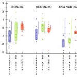
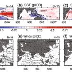
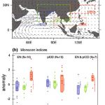
For the period 1877–2005 and focusing on the summer monsoon season, Ummenhofer et al. (2013) explored links between Indo-Pacific climate variability and drought patterns from the Monsoon Asia Drought Atlas, a network of hydroclimatically sensitive tree-ring chronologies across monsoon and temperate Asia. Distinct spatial patterns of drought across Asia were recorded, associated with leading modes of Indo-Pacific variability, such as El Niño, positive Indian Ocean Dipole (IOD), and co-occurring El Niño and positive IOD events. Drought patterns across monsoon Asia during El Niño, positive IOD, and coincident events were related to changes in three different monsoon indices, indicative of the strengths of the Indian, South Asian and East Asia-Western North Pacific monsoon systems.
Due to its location the country of Myanmar experiences influences by both the Indian/South Asian and East Asian monsoon subsystems. Myanmar is also a region with very sparse instrumental climate records and few tree-ring chronologies exist to date in the country. Newly developed teak chronologies covering the past 400 years (D’Arrigo et al. 2011) provide new insights into interannual to decadal climate variability in Myanmar and links to Indo-Pacific climate, such as the Pacific Decadal Oscillation.
Further information
Buckley BM, Ummenhofer CC, D’Arrigo RD, Hansen KG, Truong LH, Le CN, and Stahle DK (2019). Interdecadal Pacific Oscillation reconstructed from trans-Pacific tree rings: 1350-2004 CE. Climate Dynamics, 53, 3181-3196. Reprint
D’Arrigo R and Ummenhofer CC. (2015). The climate of Myanmar: Evidence for effects of the Pacific Decadal Oscillation. International Journal of Climatology, 35, 634-640. Reprint
D’Arrigo R, Palmer J, Ummenhofer CC, Kyaw NN, and Krusic P. (2011). Three centuries of Myanmar monsoon climate variability inferred from teak tree rings. Geophysical Research Letters, 38, L24705, doi:10.1029/2011GL049927. Reprint
D’Arrigo R, Palmer J, Ummenhofer CC, Kyaw NN, and Krusic P. (2013). Myanmar monsoon drought variability inferred by tree rings over the past 300 years: linkages to ENSO. PAGES news, 21 (2), 50-51. Reprint
Hernandez M, Ummenhofer CC, Anchukaitis KJ. (2015). Multi-scale drought and ocean-atmosphere variability in monsoon Asia. Environmental Research Letters, doi:10.1088/1748-9326/10/7/074010. Reprint
LeRoy E and Ummenhofer CC. (2025). Past and future modulation of the ENSO teleconnection to Southeast Asian monsoon rainfall by interbasin interactions. Geophysical Research Letters, doi:10.1029/2024GL111916. Reprint
Ummenhofer CC, D’Arrigo RD, Anchukaitis KJ, Brendan BM, and Cook ER. (2013). Links between Indo-Pacific climate variability and drought in the Monsoon Asia Drought Atlas. Climate Dynamics, 40, 1319-1334. Reprint
Ummenhofer CC, Geen R, Denniston RF, and Rao MP. (2024). Chapter 3: Past, present, and future of the South Asian monsoon. In: The Indian Ocean and its role in the global climate system, Eds. Ummenhofer CC, Hood RR, Elsevier, doi:10.1016/B978-0-12-822698-8.00013-5. Reprint
Wang S, Ummenhofer CC, Murty SA, Nguyen HTT, and Buckley BM. (2024). Quantifying the internal and external drivers of Southeast Asian rainfall extremes on decadal timescales. Climate Dynamics, 62, 9821-9841, doi:10.1007/s00382-024-07412-x. Reprint

